ESS2.B: Plate Tectonics and Large-Scale System Interactions
Maps show where things are located. One can map the shapes and kinds of land and water in any area.
Goals:
1. Students will learn to locate features of one area on a road map, topographic relief map, a USGS topographic map (if available), and compare them to a satellite view. They will be able to identify ponds, rivers and wetlands (if shown). They will note bigger roads versus smaller roadways, buildings and other man-made structures.
On the topographic relief map and the USGS topographical maps, students will also be able to identify hills and flat areas.
*You can use a map of your town, so there will be familiar places, but it is not necessary to do so. You can also use the map samples attached to this activity.
Procedures:
1. Using Google maps, print out and copy several road maps, topographic relief maps, and satellite view of the same town for your students (they can work in groups of 3-4 if you don’t want to provide each child with a map).
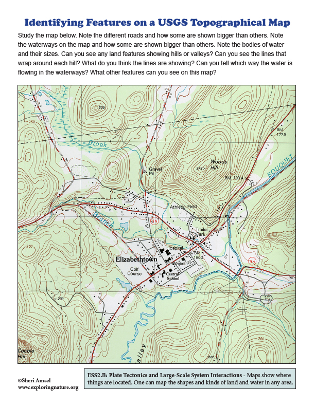
2. If you have access to one, you can also scan, print and copy a USGS topographic map of the area, (which shows more detail). This allows students to identify landforms without the 3-D relief.
3. Starting with the road map, ask them to identify several features. e.g. main road, smaller side roads, rivers, lakes, etc. If you can project each map on the wall to show them these features as a group, that would be a great way to start.
4. Next hand out (and project if you can) the topographic relief map. Let them compare the two different views of the town. Ask them to note the following features on the map:
• Hills and flat areas.
• How the hills have circular lines around them to show the steepness of each hill.
• How the closer together the lines are, the steeper the area of the hill is.
• How the downtown area of town has no lines, because people built the town on flat land.
• How the rivers also flow on the flatter areas.
5. If you can get one, show them the USGS topographic map of the area. This is a much clearer look at how the topographical lines depict land features. It also shows the waterways, including wetlands, in association to the topographical lines.
6. Lastly, you can then show them a satellite view of the same area so they can pick out the features they have been studying on the maps.
Conclusions:
Students should note that the waterways, including the wetlands shown on the USGS topographic map, are all located in flat areas, most often in the lowest elevations between the hills.
When you research information you must cite the reference. Citing for websites is different from citing from books, magazines and periodicals. The style of citing shown here is from the MLA Style Citations (Modern Language Association).
When citing a WEBSITE the general format is as follows.
Author Last Name, First Name(s). "Title: Subtitle of Part of Web Page, if appropriate." Title: Subtitle: Section of Page if appropriate. Sponsoring/Publishing Agency, If Given. Additional significant descriptive information. Date of Electronic Publication or other Date, such as Last Updated. Day Month Year of access < URL >.
Amsel, Sheri. "Maps - Learning to Use Them Activity - Grade 2" Exploring Nature Educational Resource ©2005-2024. December 13, 2024
< http://www.exploringnature.org/db/view/Learning-to-Use-Maps-Activity-Grade-2 >